The Historic Colombia River Highway is turning 100 this year and it is a great way to view the majestic and breath taking beauty of the Gorge carved by floods thousands of years ago, as well as the peaceful greenery you will travel through. If you are looking for a place to take a road trip, this is a must. Basalt cliffs, river fronts, waterfalls, and hikes galore, and not to mention the beautiful Vista House. Connecting Troutdale to The Dalles, The Columbia River Historic Highway is a must to see.
Troutdale and the Sandy:
To begin your journey from Portland, take Interstate 84 east to exit 17. Follow the signs through the quaint town of Troutdale, where you can visit elegant art galleries and unique antique shops, and then head over the Sandy River to the Historic Columbia River Highway. In 1805, Lewis and Clark camped along the banks of the Sandy, which ran gritty with ash from the 1802 eruption of volcanic Mt. Hood. The road follows the Wild and Scenic Sandy River for several miles, then climbs past orchards and blueberry fields through the communities of Springdale and Corbett, offering glimpses of snow-capped Mt. Hood.
Gorgeous Vistas from Crown Point:
At the Portland Womens Forum State Scenic overlook at Chanticleer Point, you get your first glance of the Columbia River and the Gorge: this is the vista that inspired the Highways founding father, Sam Hill. The stone guard walls and graceful arches are typical of the highways exquisite craftsmanship. The Vista House at Crown Point, just a couple miles east of the Forum, is an Oregon treasure. Towering 733 feet above the river, Vista House is one of the most photographed and recognizable locations in the Columbia River Gorge. Built as a memorial to Oregon pioneers, it offers an inspiring view of the Gorge and the mountains of the Cascade Range.
Unforgettable Falls:
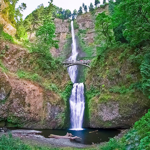
To help motorists navigate the vertical drop from Crown Point, Lancaster engineered a series of whats known as figure- eight loops that gracefully wind down towards the river. Soon you will find yourself surrounded by mossy tree limbs enhanced by a series of remarkable waterfalls, including Latourell, Shepperds Dell, Bridal Veil, and Wahkeena. Then you reach the granddaddy of the Columbia Gorge waterfalls 620-foot Multnomah Falls. Only three waterfalls in the nation are taller and none is more beautiful. A trail from Multnomah Falls Lodge (built in 1925 and listed on the National Register of Historic Places) takes you to the lower cascade, then zigzags to the top. A little farther down the road, Horsetail Falls plummets close enough to the road to mist your windows. Before the Byway joins back up with Interstate 84, at the community of Dodson, youll pass Oneonta Gorge, a botanical paradise with more than 50 species of plants that flourish in the damp, cool Oregon environs.
Bonneville Dam to Hood River:
For the next 25 miles, youll leave the Historic Highway for modern yet still beautiful Interstate 84. The Gorges dramatic geologic formations are a highlight of this segment. Engineering and fishing buffs will want to visit the Bonneville Dam, the first structure to restrain the mighty Columbia. Take exit 40 to stop by the Bonneville interpretive center to learn about the history of the dam and the fish ladder. In nearby Cascade Locks, travelers can relax with an ice cream cone or brew overlooking the Columbia, or choose to leave their car for a sternwheeler cruise of the Columbia. More intrepid water sports enthusiasts will want to head straight to Hood River. Here, the Gorge acts as a wind tunnel to create consistent breezes that have made this once sleepy orchard town the unofficial windsurfing capital of the world.
Mosier to the community of Rowena:
In the 12 miles from Hood River to Mosier, youll notice a dramatic change in the scenery. As you reach Mosier, and the second leg of the Historic Columbia River Highway (off exit 76), the moist and lush western Gorge gives way to dry, eastern Columbia River plateau. Once a booming trade center, Mosier is now famous for its springtime blossoms, fat juicy cherries, and the communitys unrivaled passion for native plants. Need a break from the car Just west of Mosier, you can walk or bike the Historic Columbia River Highway State Trail through the restored Mosier Twin Tunnels and on to Hood River. As you continue along the Historic Highway, elegant Mayerdale Estate appears unexpectedly on this rural stretch of the road. Further along, look for Memaloose Island, a traditional burial site of Native American peoples of the Columbia Basin that was partially flooded following the construction of Bonneville Dam. Farther east, be sure to linger at the viewpoint at Rowena Crest, which affords sweeping Gorge views rivaling those of Crown Point, and provides access to the wildflower wonders of Tom McCall Preserve.
The Dalles:
The Historic Columbia River Highway spans the extremes of Oregons landscape, from the damp and mossy western beginning along the banks of the Sandy River to the dry oak savannah skirting Chenoweth Creek near The Dalles. The Dalles was long a Native American gathering place and is rich in Oregon Trail lore. Before you leave the Historic Highway, as you enter The Dalles, youll find the Columbia Gorge Discover Center and Wasco County Historical Museum. Built as the interpretive center for the National Scenic Area, the Discovery Center has answers to all your questions about the Gorges history. At the Museum, youll learn about the earliest inhabitants and hear tales of the traders and settlers who came later. Explore The Dalles for eclectic shops, breweries, wineries and dining options.
Discover more attractions, events and activities you wont want to miss-out on while visiting: The Hood-Gorge Area. View other trip ideas and more information about the regions attractions and lodging before your trip to The Hood-Gorge Area in Oregon.


